Real-Time, Virtual Infrastructure Inspections
Deploy Raven across your fleet for real-time infrastructure monitoring and automated asset inventory, eliminating the need for specialized vehicles or manual inspections.
The High Cost of Reactive Maintenance Cycles
Public agencies are under constant pressure to do more with less. Raven is here to help you move from reactive cycles to proactive, data-driven decisions.
From Manual to Measurable
Replace subjective inspections with consistent, high-fidelity data capture ensuring issues are identified early and nothing gets overlooked.
Do More with Every Resource
Maximize constrained budgets with automated monitoring that reduces manual effort and helps prioritize the work that matters most.
Move Reactive to Real-Time
Move beyond complaint-driven workflows with continuous visibility that enables faster, more proactive maintenance.
Purpose-Built Solutions for Public Infrastructure

Asset Inventory
Automatically detect, classify, and geo-locate every sign, pole, and signal box. Our models identify faded text and structural tilt before they become hazards.

Road Surface Monitoring
Measure PCI (Pavement Condition Index) over time. Track deterioration rates across thousands of kilometers of roadway with automated, continuous data collection.

Compliance Engine
Automated work zone compliance, including permit validation. Ensure safety standards and signage requirements are met across all active sites.

Transitway Monitoring
Respond quickly to changing transitway conditions ranging from trash buildup to infrastructure damage.

Infrastructure Condition
Identify structural vulnerabilities across your entire roadway network. From weathered sound walls to dented guardrails.

Custom Models
Train, deploy, and scale custom models for niche infrastructure challenges.
Esri ArcGIS Integration
Push detection events into your GIS workflows and trigger work orders automatically when deterioration surpasses defined thresholds.

The 10-Second Insight Loop
Street View Capture
4K Precision Imagery
Hyper-Precise Telemetry
Edge Process and filter
Efficient Data Collection
Anonymize and Filter
automated Cloud Upload
Secure Data Storage
AI Processing

Query and Visualization
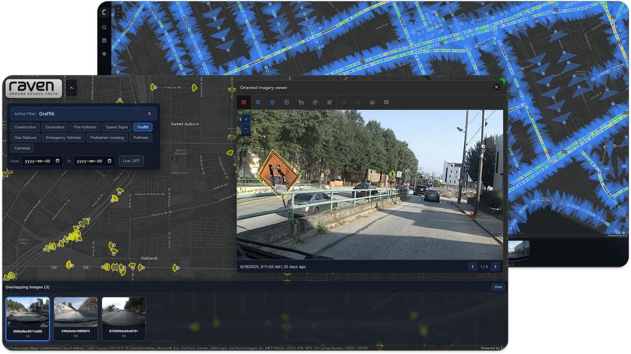
Ground Source Truth
Esri ArcGIS Integration
The Interface
Ground Source Truth
Raven’s powerful interface gives maintenance teams clear visibility into infrastructure degradation, with high-resolution imagery and built-in tools to take action.
A Multi-Purpose Platform for Every Department
Maximize your ROI by stacking solutions on the same hardware. One fleet of vehicles can simultaneously solve problems for Fleet, Public Works, and Transportation Systems Management departments by pooling budgets and resources.

Video Telematics
Improve fleet safety, protect drivers with clear exoneration tools, and support union-aligned privacy standards, all while reducing operational risk.

V2X Infrastructure
Unlock the full value of your existing connected infrastructure by enabling real-time vehicle connectivity, creating a responsive, bidirectional V2X network without heavy new investment.
Bring Clarity to Infrastructure
Book an exploratory call to see how Raven’s AI-driven road insights can optimize your workflows.
Latest News