
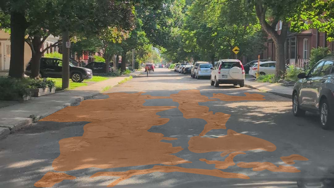
Every year, as seasons change and weather takes its toll, state and local government officials brace for the inevitable: a flood of 311 complaints about potholes and damaged streets. Currently, 1 in 5 roads in the U.S. are in unacceptable condition. For the public agencies and public works teams responsible for managing these roadways, this is more than just a nuisance, it’s a massive logistical and financial strain.
The number of citizen 311 complaints is skyrocketing, yet many municipalities lack the efficient workflows necessary to keep up. The result? Frustrated residents, stretched budgets, and infrastructure that continues to deteriorate. But the core issue isn’t a lack of effort from road crews; it’s a reliance on outdated, reactive methods to identify and prioritize damage.
The Flaw in Traditional Road Surface Surveys
When managing road surface quality, cities typically rely on two primary methods, both of which have significant shortcomings:
- Reactive 311 Complaints: Relying on citizen reports means your agency is perpetually playing catch-up. Furthermore, 311 complaints don’t necessarily dictate the most urgent or severe spots, they simply highlight where the most vocal residents happen to drive. A 2024 study published in the Policy Studies Journal confirms that 311 data is heavily skewed and inherently unreliable for determining actual surface quality. Additionally, the researchers found that communities with lower socioeconomic status and higher percentages of minority residents are significantly less likely to initiate 311 reports. Crucially, the study revealed that these exact same under-reporting neighborhoods actually experience a greater number of potholes. When agencies treat 311 call volume as a proxy for actual infrastructure needs, they inadvertently exacerbate inequities, resulting in skewed priorities and a cycle of decreasing road quality in the communities that need maintenance the most.
- Expensive Annual Surveys: To get a more comprehensive view, agencies often spend large sums of money on in-depth pavement surveys. While these highly detailed assessments are valuable for gaining a deep, engineering-grade understanding of long-term infrastructure health, they require specialized, expensive equipment and custom vehicles. Because of the sheer cost, these surveys simply cannot be performed at an action-oriented interval. Most mid-to-large-sized cities perform these detailed surveys every 2 to 3 years. Very small municipalities often push their cycle to every 4 to 5 years.
- Need for higher cadence, complementary surveys: For addressing dynamic issues like potholes, agencies rarely need millimeter-level perfection; a reliable, frequently updated general sense of surface conditions, and how these conditions align with the data and degradation curves from the detailed surveys, strikes a balance. Roadways are unpredictable. Damage severity changes rapidly with weather, freeze-thaw cycles, and heavy traffic. Potholes don’t surface just once a year and stay in a manageable state. An annual or biennial survey is functionally obsolete just months after it’s completed, leaving agencies without the actionable, up-to-date data they need to allocate limited resources effectively.
Meet Your New Virtual Inspector
Agencies need a better way to gauge the urgency and severity of road damage without breaking the budget. With tightening financial constraints and increasing request volumes, cities need a reliable workflow to identify, categorize, prioritize, and dispatch work orders in order of actual urgency.
This is where Raven steps in. Raven solves this challenge by turning the vehicles you already own into a fleet of virtual inspectors.
- No Specialized Equipment Required: Raven devices are equipped directly into your existing fleet vehicles, from garbage trucks to street sweepers and utility vans. There is no need for expensive, single-use vehicles dedicated uniquely to road surveys.
- Continuous Scanning: As your fleet goes about its normal daily routes, Raven devices passively scan the road networks, roaming the streets like a virtual inspector.
- The Ground Source Truth Platform: This continuous feed of data populates the RAven Ground Source Truth platform. It provides a centralized, real-time ecosystem that allows different municipal teams to cross-collaborate. Because the data is queryable, the use cases stretch far beyond just potholes, teams can address everything from post-storm cleanup and guardrail damage to downed signs and right-of-way concerns. With its advanced AI, APIs and deep integrations into ESRI ArcGIS, the platform can provide solutions to an expansive set of workflows.
Proactive Prioritization with the Raven PASER App
While the Ground Source Truth platform provides an overarching, queryable view of your city’s infrastructure, Raven provides specific app workflows built on top of it for end-to-end operational control.
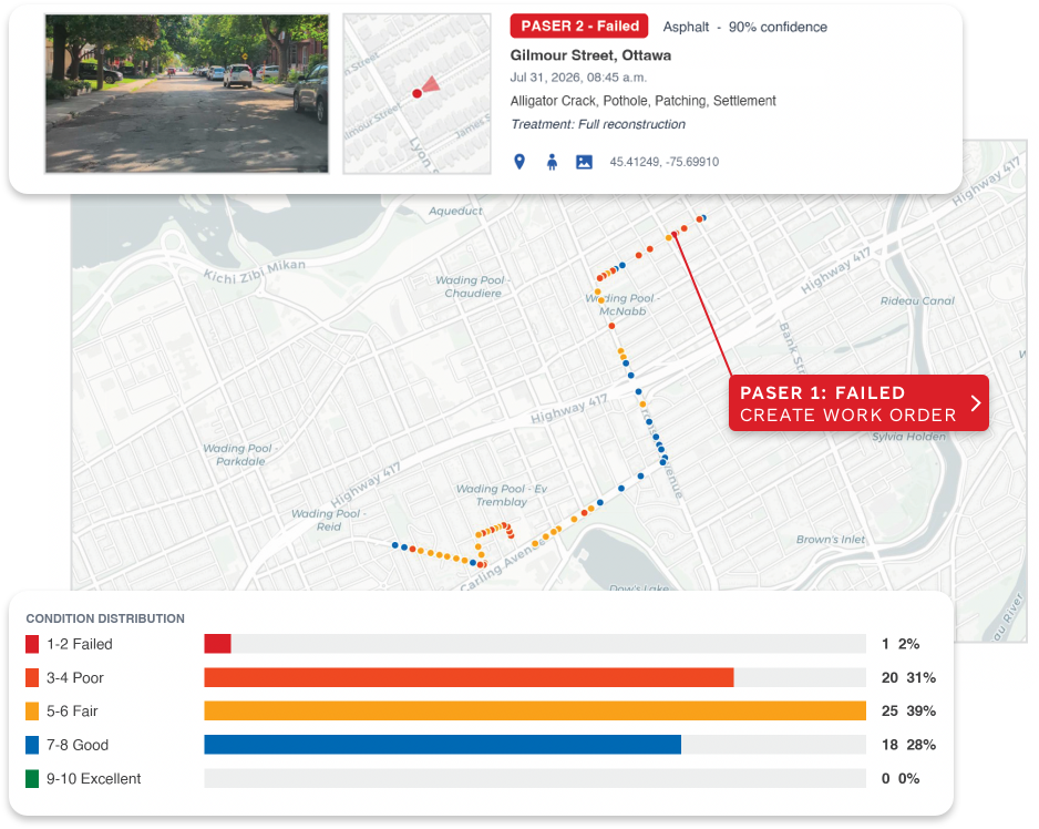
For road surface quality, the Raven PASER App allows teams to specifically index and address issues on a real-time basis. Instead of guessing which pothole needs immediate attention or waiting for the 311 board to light up, the PASER system automatically evaluates, categorizes, and ranks road conditions.
This streamlined workflow enables municipalities to:
- Identify new damage as soon as a fleet vehicle drives past it.
- Categorize and Prioritize the urgency of work orders based on actual damage severity, not just complaint volume.
- Dispatch crews efficiently to fix the worst offenders first.
From Reactive to Proactive
The days of reacting to angry citizen calls or relying on stale, year-old survey data are over. By leveraging your existing fleet and real-time data, Raven empowers state and local governments to address roadway challenges proactively. You can finally gain control over your infrastructure, prioritize effectively, and most importantly, repair the worst offenders before a 311 complaint is even triggered.
Addressing road surface quality is only the first step. The true power of Raven lies in the ability to value stack the Ground Source Truth platform across your entire municipality. While the PASER system gives your road crews end-to-end control over potholes, that exact same continuous data feed can equip other departments to tackle entirely different right-of-way concerns simultaneously.
There is no reason for civic workflows to operate in silos when the intelligence is already driving your streets.


Comments are closed